Sunday, June 22, 2014

West Bragg Creek

Trip Date: June 2014


Just last weekend I had my first biking experience at West Bragg Creek Provincial Recreation Area, which is part of the Kananaskis Parks System.  I'd heard nothing but great things about the trail system that's in place there and I was not disappointed!  West Bragg Creek is approximately 55km west of Calgary along the West Bragg Creek Road, which is just off of Highway 22.  I met a co-worker (Mike) at the gas station in Bragg Creek and then we were off to the trailhead.  

The south trail system of West Bragg Creek
We started off by riding up the Ranger Summit Trail.  This section was basically all uphill, but the ride down via Suger Mama (unmarked) towards Elbow Trail made the climb more than worth it!  We followed Elbow Trail until it intersected with Boundary Ridge Trail.  Here we did another leg-burning climb until we topped out somewhere along Boundary Ridge.  From there it was all downhill back to the parking lot.  In total we did approximately 15km on our bikes.

This lookout is approximately halfway up the Ranger Summit Trail
Looking towards Moose Mountain from the lookout
Ranger Summit Trail
A section of the Ranger Summit Trail (Photo Credit: Solitary Images from Bragg Creek & Kananaskis Outdoor Recreation)
Another section of the trail (Photo Credit: Solitary Images from Bragg Creek & Kananaskis Outdoor Recreation)
The leg-burning climb up Boundary Ridge (Photo Credit: Bike Pirate)
The trail along the summit of Boundary Ridge (Photo Credit: Solitary Images from Bragg Creek & Kananaskis Outdoor Recreation)
You know it's been a good day on the trail when your bike comes home looking like this!
I had such a good day in West Bragg Creek that'll I'll definitely be going back!  Looking forward to exploring all the other trails that the area has to offer.

Recently I did a story for Calgary Guardian called Bragging Rights about the mountain biking scene in the Bragg Creek area.

Saturday, May 31, 2014

Sir Winston Churchill Provincial Park

Trip Date: May 2014


I was selected to attend Inside Education's Living on the Landscape professional development program in the Lac La Biche region of the province.  While we were there we had the opportunity to spend some time in Sir Winston Churchill Provincial Park.  To read about the entire professional development program please visit my other blog by clicking here.  Although we didn't have a lot of time to explore the park I was able to get out for a short hike.  

Map of Sir Winston Churchill Provincial Park
Sir Winston Churchill Provincial Park is located approximately 545km northeast of Calgary in east-central Alberta.  It is Alberta's only island park and it's located in Lac La Biche Lake.  To access the park you have to drive the 2.5km causeway from the town of Lac Lac Biche.  The park is covered by a 300-year-old forest and the shoreline is made-up of beautiful sandy beaches.

Beach day-use area in the park
There are a few trails within the park, but I chose to hike along the north shore on the Old Growth Alley trail.  The trail was beautiful with some great views of the lake.  There were signs of moose (tracks and scat) all over the place, but I didn't see any of them.  

Small sections of the trail had boardwalks that crossed swampy marshland
The park is a birder's paradise.  It provides habitat for more than 230 species of bird.  I spotted a few during my hike, but I heard the songss of countless others.  Here are a few photos that I managed to get of a couple of different species.

I think this is a female Red-Winged Blackbird
There were a lot of Gulls flying around
This Pelican was soaring over the water looking for it's next meal
One of the two Pelican Islands just off the shore of the park
I saw this sign as I started the Boardwalk Trail loop.  I'm glad I didn't run into the Cougar.
A section of the 1.5km Boardwalk Trail
The trail lead to this secluded beach
Shoreline
The day was cloudy, but very warm
Back at the beach where I started
Although I would have liked to explore more of the park, it gives me a good reason to come back to this part of the province in the future.

Wednesday, May 7, 2014

Time Lapse Photography


Time-lapse photography is a technique whereby the frequency at which frames are captured is much lower than that used to view the sequence.  When played at normal speed, time appears to be moving faster and thus lapsing.

I was inspired by a co-worker's time-lapse photography to give it a try on my own.  If you'd like to see the video clip that really inspired me, you can view it here.  I already had everything I needed, except the remote timer (intervalometer), but I was able purchase one online.  Once it was delivered it was time to give it a whirl.  Below you'll see my third and fourth attempts at time-lapse photography.  The first two aren't even worth viewing.  The interval timing was off and the photographs were too overexposed, but these two didn't turn out half bad.  

This first video combines 1,079 still photos into a relatively short 36 second clip.  The camera was turned to Manual mode and after I'd adjusted for the proper exposure I set the remote timer to take a photograph every 10 seconds for approximately 3 hours.  I imported the photos into GoPro Studio, a video editing program, rendered them together, and finally exported the finished copy as a video file.  See for yourself...

For the above video I set-up my camera in the meadow outside of camp.  The mountain in the frame is Black Rock Mountain.

This second video combines 977 still photos into a 33 second segment.  This time I set my camera to Aperture Priority so it would automatically adjust the shutter speed for the changing light conditions.  The remote timer was set to take one picture every 8 seconds over the course of about 2 hours.  After editing the photographs together I was rewarded with the following...

For this clip I set-up the camera on the far side of the meadow just before sunset.  The small mountain on the left is Sleeping Mole and the bigger mountain in the centre is Black Rock.

As I mentioned before this was my first foray into time-lapse photography, but I have really enjoyed it so far.  I'm hoping to experiment a little more with sunrise/sunset and hopefully photograph a few overnight scenes as well.  Stay tuned for more to come!

Tuesday, April 8, 2014

Canada Olympic Park

Trip Date: April 2014


Canada Olympic Park (COP), formerly known as Paskapoo Ski Hill, was the premiere site when Calgary played host to the XV Olympic Winter Games in 1988.  The Calgary Olympic Development Association (CODA), known today as WinSport, renovated the site in preparation for the Games, and now the park is the most visible reminder of Canada's first chance to host the Winter Olympics.  Today the park is operated by WinSport and the grounds are home to several facilities for amateur and national team athletes in training, such as ski jumping, alpine racing, aerials, moguls, halfpipe, cross-country skiing, bobsleigh, luge, skeleton, and ice hockey.  The Calgary Gymnastics Centre, the High Performance Training Centre, Canada's Sports Hall of Fame, and the Ice House also call COP home.  The park is also open to individuals of all ages and abilities for winter and sport recreation opportunities.

Canada Olympic Park Map
I have visited the park on two previous occasions; one for the World Push Challenge and the other as a field trip to the Hall of Fame.  This visit, however, was to go snowboarding with my cousin (Shawn) and his three kids (Sidney, Lydia & Lucas).  It marked the first time that I had ever snowboarded at COP and I was looking forward to experiencing the park in a different way.  Although it is very much a beginner hill, it was perfect for the kids, all of whom haven't been on skis very many times yet.  And let's be honest, any time you spend on your board is a good day, regardless of the terrain!  We rode the Legacy Chair Lift a couple of times to warm-up the legs and then spent the rest of the day doing laps off of the '88 Express.

Canada Olympic Park Trail Map
Canada Olympic Park's ski/snowboard terrain
Ski Jump Towers
View from the very top
Lydia practicing her snow plow
Sidney heading down the blue run
Frank King Day Lodge
It was a beautiful Spring day in Calgary and the weather was perfect for being outside.  After wrapping things up on the hill I spent a few minutes exploring the area around the hill before heading to the car.  I found the Olympic cauldron on display as well as a couple other treasures.  Keep reading to see them all for yourself...

Olympic Cauldron in the International Flag Court
The plaque on the cauldron reads, 
"This cauldron burned with the sacred Olympic Flame saluting the athletes of the world at the XV Olympic Winter Games, Calgary 1988.  Ignited on February 13 at 1900 hours.  Extinguished on February 28 at 1030 hours.  Cauldron and fuel provided by Canadian Western Natural Gas Company Limited."
Share The Flame monument honoring Petro Canada's Olympic Torch Relay at the 1988 Winter Games
Feel the Rhythm, Feel the Rhyme! The actual bobsled used for the filming of Cool Runnings.
Basically the only snow left in Calgary resides at COP.  As soon as it's all melted it'll be time to get the bikes out.  I'll have to do some trail riding at COP and experience the park in a whole other way.

Recently I did a story for Calgary Is Awesome about Alberta's epic skiing and snowboarding titled: Skiing & Riding.

Monday, March 31, 2014

Kananaskis Lakes Trails

Trip Date: March 2014


Christine and I decided to get outside and do some cross-country skiing.  This day-trip marked a few firsts for both us.  It was Christine's first time up on skis this season and it was also her first time cross-country skiing at Pocaterra in Peter Lougheed Provincial Park.  This was my tenth day out on skis this season, but it was my first without having Rome by my side.  Dogs aren't allowed on the groomed trails at Pocaterra, so sadly we had to leave her at home.  I had been to Pocaterra previously, but hadn't skied there in almost seven years.  The spring floods in 2013 had destroyed different sections of the trail system, so it looked a little different than how I remembered it.  

The system of trails in Peter Lougheed Provincial Park
The Pocaterra parking area is about 140km southwest of Calgary along the Kananaskis Lakes Trail (Highway 40).  Pocaterra is a great skiing area with different trails to suit all abilities.  It is part of the Kananaskis Lakes Trail System.  We ended up skiing a 10.5km loop that connected Pocaterra, Come Along, Lynx, Amos, and Lodgepole Trails.

The entire drive from Calgary featured wet, falling snow, but almost as soon as our boots were snapped into our bindings the sun started to breakthrough the clouds and gave us some spectacular spring weather.  The sunshine and warm temperatures remained for the majority of our trip and it wasn't until the last section of our loop that the weather turned on us.  The wind picked up and the snow started to fall again, luckily we weren't too far from a warm vehicle and some delicious snacks!

The clouds started to break-up, which gave us some great mountain views
Just getting our day started
Views along the Pocaterra Trail
A hilly section of the Lynx Trail
Christine at the top of a hill
Skiing down
Untouched snow in a small meadow somewhere along Amos Trail
The shower house in the Elkwood Campground was covered in a lot of snow!
On our way back.  This must have been just before the weather turned on us.
Overall it was a pretty great day of spring skiing, although the loop we chose may have been a bit over ambitious for Christine's first day of the season.  We are hoping to get out at least once more before all the snow melts.  Finger crossed!

Tuesday, February 4, 2014

GOT Parks


In January of this year, I was fortunate enough to be accepted as a new Team Member for GOT Parks.  GOT (Get Out To) Parks is a joint initiative of the Canadian Parks Council and the Child & Nature Alliance of Canada.  Their ultimate goal is to provide an online destination for young people to learn about Canada's National, Provincial, and Territorial parks and to encourage Canadian youth to get outside and experience parks firsthand!


The initiative was started in December of 2012 with a website designed by young Canadians for young Canadians.  An Advisory Group was formed from a group of people who were passionate about better connecting youth with the beautiful parks Canada has to offer.  The Advisory Group, which is now known as the GOT Parks Team, were responsible for assisting in website maintenance, providing fresh ideas and feedback, and ensuring the site stayed true to its audience. 

As a Team Member I have to be an active participant in promoting and marketing GOT Parks by contributing to their webpage and various social media sites.  If you'd like to stay connected with what GOT Parks is doing, please visit the website or follow us on Twitter, Facebook, or Instagram.  

Enjoying Canada's parks through a variety of my favourite activities!
I am really looking forward to this opportunity of working with the GOT Parks team.  I hope we can continue to build on this initiative and encourage young people to experience Canada's parks for themselves!

You can see an update about my time with GOT Parks right here.

Thursday, January 9, 2014

Last Mountain House

Trip Date: December 2013


A couple of days after my visit to Condie we decided to rent some cross-country skis and spend another afternoon outside.  Our original plan was to head out to Last Mountain House, ski through the coulee, and explore the site.  There are only two shops in Regina that rent skis and, unfortunately, both of them were entirely rented out, so we would need to revert to Plan B.  Our new plan would be to still head out to Last Mountain House and do a little exploring at the old site, but instead of skiing, we'd be doing some snowmobiling.  My brother Kyle has his own sled and our cousin lent us hers so we ended up with two, which worked out perfectly.  It had been a year since I was last on a sled, but I had so much fun that time, I was looking forward to doing it again.  After the initial disappointment of not being able to ski, things were shaping up to be a fun day outside after all.  Last Mountain House is located approximately 45km northwest of Regina along Highway 20.  Over the summer they offer interpretive programs and a chance to go inside the buildings.  Unfortunately everything was closed while we were there, but that didn't stop us from just looking around.

Last Mountain House Historic Park
Last Mountain House was built by the Hudson's Bay Company in 1869 as a winter outpost for it's Fort Qu'Appelle operation.  The post almost feels like an afterthought, since the fur trade had been operating for almost a century in western Canada by the time Last Mountain House was constructed.  The Hudson's Bay Company deemed the post necessary because its competition was moving in on its territory and the Bison herds were moving southwest.  

Last Mountain House as it appears today
Situated on a high plateau above Last Mountain Lake, the location provided all the necessities needed to sustain it.  Wood collected from the nearby coulee was used for building material and firewood, fish and waterfowl from the lake provided a source of sustenance, natural springs from the ravines provided drinking water, and grasses fed the livestock.  
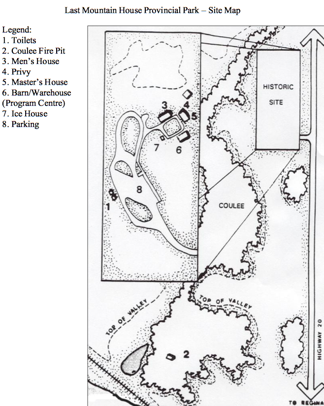
A map of the Last Mountain House area
The outpost housed a clerk, a Postmaster, various servants and their families.  The first year the post was operational (1869) was a very prosperous one.  The post was used as a base to hunt Bison and trade for dried meat, grease, and pemmican; the staples of the fur trade.  Its primary role was to send these provisions, or food, to the Hudson's Bay Company's more northerly outposts.  Unfortunately, one good year was all this outpost would see and it was abandoned sometime in the early 1870's.  The Bison herds continued moving westward, the sale of HBC lands to the Canadian government, and the Red River Rebellion all played major roles in the closure of this outpost.  At some point in the 1870's the post eventually burnt to the ground and was never rebuilt.  The buildings that make up the site today were built on their original locations sometime in the late 1960's or early 1970's and have been used to interpret the fur trade ever since.

The Men's House
The Men's House was divided into two sections; the Single Men's Quarters and the Married Men's Quarters.  The Single Men's Quarters resembled a bunkhouse.  Walls were covered with everything from winter clothing to kitchen utensils.  The furniture was simple, usually just bunks and a table.  The number of men living there varied.  Temporary servants and men helping on trading trips were constantly coming and going, lending an air of transience to the place.  

Married servants and their families probably occupied two of the three apartments in the Men's House.  As many as two couples and their children squeezed into this 4 x 5 metre (12 x 15 foot) room.  Even though the men often worked away from home, privacy and solitude must have been unheard-of luxuries.  

The Master's House
Issac Cowie, clerk-in-charge, shared the Master's House with Postmaster Joseph McKay and his family.  Here Cowie worked on the accounts and directed daily activities.  McKay, however, was often away on trading trips.  

The relatively large building with its separate kitchen clearly shows the wide gap that existed between officers and men in fur trade society.  

The Privy was located outside the Master's House
The Barn/Warehouse
The exact use of this building is not known.  The daily journal states that a barn was built at Last Mountain House, however, Issac Cowie's memoirs indicate that the warehouse and trade shop were located here, on the south side of the post.  It is possible that this building may have served both purposes.  

The foundation of the Trade Shop
Cold hard credit best describes the trade for pelts and pemmican.  Cash was not used.  Written accounts of credit and debt were kept through the winter and balanced each spring.  It was cold work because the building was never heated.  The barrels of gunpowder stored here made using a stove or fireplace way too dangerous.

The Fur Press
For efficient transportation, bulky items like buffalo robes had to be tightly packed.  To operate the Fur Press the men lifted the long boom pole and placed folded buffalo robes in the space below.  Then they "lowered the boom" and pressed it down to squeeze the robes into a compact bale.

The last structure at Last Mountain House is the Ice Cellar.  It was used to store perishable items so they would last longer.  The cellar was completely buried under deep snow so we weren't able to see it.  

The nearby coulee that we wanted to ski through.  You can see Last Mountain Lake in the background.
Christine spotted this Coyote running along the hillside on the opposite side of the coulee
After thoroughly exploring the historic site and viewing the coulee it was time to go sledding!  We unloaded the snowmobiles and headed north, riding in the ditches beside the highway.  We rode through the beach-side community of Kannata Valley and gained access to frozen Last Mountain Lake.  Here we discovered a snowmobile highway that traveled as far as the eye could see in both directions.

A very frozen Last Mountain Lake and the snowmobile highway that stretches along it
Last Mountain Lake, also known as Long Lake, is the largest naturally occurring body of water in southern Saskatchewan.  It is approximately 93km in length, but only 3km across at its widest point.  I have spent countless hours swimming, fishing, and boating on this lake, but this would mark the first time actually snowmobiling on top of it!  

Kyle riding along the lake
We turned and headed southeast towards the small town of Craven, not really knowing what to expect.  We followed the lake shore until we reached Last Mountain Creek.  We followed the frozen creek's twists and turns until we reached Craven.  From there we turned around and headed back the same way we came.

Just relaxing in my cozy La-Z-Boy recliner!
Kyle playing in the snow on the banks of the creek
Back on the lake
Me, enjoying every minute of it!
We only did about 30 miles on the day, but it was enough to satisfy my need for speed!  Hopefully I'll get another chance to go for a ride before the winter is over, but if not, there's always next year!